Unlike other types of queries, Reports can be based on multiple object types at the same time. Reports thus make it possible to retrieve and present information from several tables in the database in one and the same result. This means that individual entries in the results window can contain a compilation of data from several different objects, and not just single objects as in the other query types.
Reports are predefined selection queries created in SQL or Java by Digpro and/or by the system administrator. This means that you as a user can only run and use the results of reports, not create new ones or edit existing ones.
|
Reports do not always have a connection to the map, it is not always possible to display or read the result of a Report in the map. |
Generate a report
1.Select Tools > Query Tool.
2.Select the Reports tab..
3.Select the desired report.
4.Enter one or more selection criteria in the text boxes next to the field names. Text boxes in pink are mandatory and must be filled in.
5.In the drop-down list Result as, you can choose to display the result of the report in the form of a Table/Tree or write the result directly to a File, for some reports you can show the results in a Chart.
6.Press Search. The result of the search is displayed in the results window.
Show results as file
In cases where you can expect a very large amount of results, you can choose to write the entire result directly to a file, without the entire amount being written in the results window.
1.Prepare a report according to section Generate a report above.
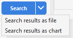
2.Press the arrow to the right of the Search button, or right-click the button, and select Search results as file. A dialog opens.

3.Enter the file name and file format.
4.Enter the field separator (without quotes). Example: ";" "tab".
5.Press Save.
Show result as Chart
1.Prepare a report according to section Generate a report above.
2.Press the arrow to the right of the Search button, or right-click the button, and select Search results as chart. A dialog opens.
3.Select your desired options and press Show. The chart is displayed.
|
In the chart window, press Display value |
Save report
You can save reports that you, for example, want to generate frequently. The reports you save are placed in the User reports folder. Reports under User reports are linked to your personal user profile, only you have access to them.
1.Select a report and enter one or more selection criteria.
2.Press Save. The report is saved as a sub-report of the report you started from and added to the User reports folder.
Share a saved report
1.Right-click on the report under User reports and select Share. The report is added to the Shared reports folder and is now shared with the rest of the organization.
|
To stop sharing a report, right-click on the report and select Stop sharing. |
Copy a shared report to your own reports
1.Right-click the report under Shared reports and select Copy to my reports. A copy of the report is created and added under User reports.
|
To see who shared a report: Hover the mouse pointer over a report under Shared reports. |
Add a report to Favorites
All types of reports, general, saved and shared, can be added to a favorites list.
1.Right-click on a report and select Add to favorites > [desired favorites list]. The report is added to the selected favorites list.
|
To add a saved report to a shared favorites list, you must first share the report, otherwise it will only be shown to you. |
More information
You can select which columns to display. Press the icon ![]() at the far right in the table's header row and select or deselect columns. This way you can customize the report for your specific purpose. See section User interface > Tables.
at the far right in the table's header row and select or deselect columns. This way you can customize the report for your specific purpose. See section User interface > Tables.
If the report contains coordinate data, such as the dpPower report Stations with coordinates, you can choose to save the result as a GPX file. It can then be read into external programs or into a GPS device.
See section Troubleshooting reports and its subsections for descriptions of various troubleshooting reports you can use.