File format |
Version support |
Usage/Comments |
|---|---|---|
DGN |
Microstation v7 |
Import, export and reference data. |
DXF |
dpSpatial follows the development of the format and handles the latest versions in best effort. |
Import, export and reference data. |
DWG (Drawing) |
dpSpatial follows the development of the format and handles the latest versions in best effort.
|
Reference data.
|
DPS |
|
A vector format developed by Digpro. Used among other things for exchanging data between dpPower and the dpFieldmap client (offline). |
Geo data with attributes |
|
Import and export of coordinate data. |
Geodos |
|
Import and export of coordinate data. |
GPX (GPS Exchange Format) |
|
Reference data, export of coordinate reports in the query tool. An XML based standard format for exchangning GPS data in terms of dots and slot between different applications. |
GSI |
|
Import and export. GSI is a measurement data format from total stations of Leica brand. |
JPEG |
|
Reference data and export of graphical view. Suitable for export of raster data. |
KRF |
|
Reference data. KRF is Kartago raster format. |
KML (Keyhole Markup Language) |
2.1 |
Reference data. The system supports point data, lines and some types of polygons. |
Marit |
|
Import and export of coordinate data. |
PNG (Portable Network Graphics ) |
|
Reference data and export of graphical view. Suitable for export of raster data. |
|
Export of reports, pictures etc. |
|
PXY |
|
Import of coordinate data. |
RDW |
|
Reference data. |
Shape |
|
Reference data, export and import. |
SVG |
|
Export of data in the graphical view. SVG is an XML-based vector format. |
SQL |
|
Import and export of map product and product classes. |
TAB |
|
Reference data, MapInfo. |
Trimble |
|
Import and export of coordinate data. |
TXY |
|
Reference data. See section TXY Specification below. |
XLM |
|
Import and export of product specifications, codelists etc. |
XLS (Microsoft Excel) |
|
Export of tables, search results, etc. |
TXY Specification
The TXY-format is a vector based coordinate format using a semicolon separated values of 3 or 10 columns. TXY files may be opened as reference files in the application and are handled in much same way as other available reference files of the vector type. When a TXY-file is opened in the application, its coordinate point data is shown as symbols, whose color, size and shape may (optionally) be defined in the file. The TXY reader used in the application also supports comma-delimited files with the "*.csv" file extension that conform to the txy format specification as outlined below.
TXY format specification:
1 |
Free text (identifier); |
|
2 |
X (N); |
Columns 1 through 3 (mandatory). Describe the geographic position of point data. |
3 |
Y (E); |
|
|
|
|
4 |
Primary color; |
|
5 |
Secondary color; |
|
6 |
Symbol font; |
Columns 4 through 10 (optional) describe the symbols (color, type, size) used to visualize point data. |
7 |
Symbol-ID; |
If the columns are left out, point data will be given a common, default symbol. |
8 |
Height, |
|
9 |
Width; |
|
10 |
Style |
|
Example of data row in the TXY file:
"Gas boiler;10099.123;97875.245;00FF00;00EB00;FV107;DEC132;4.2;4.2;0"
Support for cvs-files:
The TXY reader can be used to open comma-delimited files (*.csv) created in e.g. Excel. The csv file must conform to the format specification given above. Additionally, the following applies to csv-files:
* If columns are separated with ';' the decimal separator can be '.' or ','
* If columns are separated with ',' the decimal separator can only be '.'
Specifications for measurement data file format
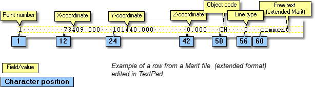
Marit
This format is used originally by the Geograph ME application. The format supports point objects, lines and polygons.
The file extension is "*.xyz" eller "*.pkt". The Marit-format has an extended format "*.ext" (extended) with an extra "Free text" column.
Specification Marit:
Field |
Description |
Point number |
Can contain both, letters and numbers. Max 7 characters. Character position in the source file: 1. |
X |
X-coordinate (northing), max 11 characters. Position: 12. |
Y |
Y- coordinate (easting), max 11 characters. Position: 24. |
Z |
Z – coordinate (elevation), max 11 characters. Position: 42. |
Object code |
External code (field code) for the input object. Position: 50. |
Line type |
A single-digit number code denoting the geometric type of a coordinate point See table Line type codes Marit. Position: 56. |
Free text |
An extra field available only for extended Marit format with file extension ”.ext”. Position: 60. |
Line type codes Marit:
Line type |
Description |
|---|---|
0 |
A point object, such as a manhole. |
3 |
A point on a line or polygon (area) object. Forms a vertex on a line segment. |
4 |
A point on an arc. |
7 |
An end point in a polygon/area. Connect this point to the first point to create a polygon. |
8 |
An end point on a line. A line consisting of three segments will have four coordinate points with line types 3 - 3 - 3 - 8, in that order. |
|
Make sure to show formatting marks |
Geodos
Geodos is a computer system for measuring technology in surveying, building and construction activities. The system is primarily used to run on field computers.
The file extension is "*.xyz".
Specification Geodos
Field |
Description |
Punct number |
Can contain both: letters and figures |
Object code |
External code (field code) for the input object |
X |
x-coordinate |
Y |
y- coordinate |
Z |
z – coordinate |
|
The field is separated by at least one space. |
Example:
6 dp 6167270.546 1323734.769 6.536
7 dp 6167270.191 1323728.182 6.562
8 cabinet 6167270.115 1323726.592 6.4
Stp
Standard for the Exchange of Product Data (STEP)
The format is used only for point objects.
The file extension is ”*.stp”
Specification stp:
Point number X-coordinate Y-coordinate Z-coordinate
Example:
RL7_S2__STV 6934655.220 1493483.110 162.940!
RL7_S2_0001 6934613.370 1493515.490 161.400!
RL7_S2_0002 6934502.300 1493477.930 159.720!
RL7_S2_0003 6934256.430 1493394.630 157.430!
RL7_S2_0004 6934056.130 1493327.080 163.780!
When you use the function, the object code for the new object has to be added.
HP-17
The file extension is ".17".
Specification HP-17:
Type codes
L = Line
LE = Line end
T = Text
P = Point
Format
For the L type code
L,Object Code
X-coordinate 1,Y-coordinate 1
X-coordinate 2,Y-coordinate 2
X-coordinate n,Y-coordinate n
LE
For the T type code
T, Object Code, Rotation, X-coordinate, Y-coordinate, Text
For the P type code
P, Object Code, Rotation, X-coordinate, Y-coordinate
Example of an HP-17 file:
P,DP1,0,6556280.806,1458602.458
P,POL,0,6556289.549,1458609.815
P,POL,0,6556265.879,1458636.684
Topocad
The file extension is ”.dpt”
Every row in the file corresponds to a point or vertex, and is designed as below:
pbet;X;Y;Z;objkod;linjenr;radie;attr1;attr2;attr3;attr4;attr5;attr6;attr7;attr8;attr9;attr10
A vertex in a line object should have a value on the field "line number". Points with the same line number belong to the same line. If the line number is missing, the row is handled as a point object.
The radius is used only for circular arcs
GSI
The GSI format may contain measurements of angles and distances, as well as coordinates. dpSpatial supports only coordinates. When importing GSI files, field objects are read as field data objects (object type 14005).
The file extension is ".gsi"
Example of a point row in a GSI file:
*110001+0000000000116420 81..10+0000000103307321 82..10+0000000074416531 83..10+0000000000000000
Parameters (in fat style in the example above):
* = beginning of a row, describing a point.
11 = point number.
81 = Northing
82 = Easting
83 = Height