These sections describe the basics of documentation and editing, the most common methods of creating new objects, how you can change an object's geometry in the map, and how to use attribute forms to specify and edit other properties of an object.
If you have never worked with creating and editing objects in dpPower before, please first read the Objects and the Components sections below before proceeding with any of the other sections.
Object types
All data in dpPower is organized according to different types of objects that represent and describe the elements of NIS and GIS operations. It is at the object level that you work when documenting network elements or performing analysis, such as tracing connections or finding faults.
From a user perspective, an object can be a unique wire, cable, fiber or property that has geographic characteristics such as location and extent on the map, and its own attributes such as ID number, address, voltage level, height, cable type, pipe dimension, and so on.
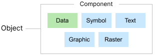
The actual building blocks of dpPower however, are components. A database object is made up of one or more components that together describe the attribute data and geometry of the object. All components included in the same object have the same system ID.
We can use five types of components to build objects. Four of them are graphical components, which can be displayed in the graphical view: symbol, text, graphic and raster components. The fifth type is the data component, which has no graphics but contains other important information about the object.
Subtypes
Many object types are divided into different subtypes. A subtype describes a variant of a particular object type and is used to distinguish objects with different properties or functions.
The subtype affects which components and attributes are used, as well as how the object is visualized in the map.
By combining an object type, a subtype and a component type, a component is created. Together with other components that have the same system ID, the component builds a unique database object.
Component types
Graphical components
Central to the functioning of GIS/NIS applications of all kinds is the management of data linked to a certain geographic position. At least as crucial is the possibility of visualization of geographic, or spatial, data in digital maps. In order to be visualized, the objects that make up our map data must have some kind of graphics.
A map object in most cases has at least one, but usually several graphic components, that is some kind of graphics that can be seen in maps and graphic views. Different types of point data, for example a node, base point, or a well in the map are usually graphically represented by a symbol component and a text component. The symbol can consist of a circle or a rectangle and shows the location of the object on the map. The text usually describes the object's ID.
Other types of objects are visualized using graphic components. There are two kinds of graphic components, lines and polygons. Examples of object types that are shown with lines in the map are wires of various kinds, electric cables and district heating lines. Examples of object types that are displayed with polygons are for example properties, work areas and concession areas.
The fourth and final type of graphic component used is the raster component. The raster component is an image with defined corner coordinates, and together with a set of data components builds up a raster object.
Important to note is that an object can be made up of many different types of components. An object can also consist of several components of the same type. When an object is created, in most cases it gets at least one graphic component, typically a symbol and a text, and always at least one data component, the so-called primary component.
You create and edit graphic components in the graphic view, in connection with placing objects or placing components to an object.
Data components
Each map object also includes a large amount of non-graphical attribute data that cannot be visualized in the graphical views, and which describes a number of other properties of the map object in addition to purely geographical properties. Such attribute data is held in data components. Examples of attribute data are ID, street name, state, location accuracy data, data about linked documents, and how the object is connected to other objects.
Mandatory data components, such as primary component and terminal data, are automatically created when you create an object. There are also non-mandatory data components, such as linked documents, which are created manually. You can create and edit attribute data using the object's attribute form.